Frequently Asked Questions
Are you going to go away and leave this undeveloped dirt?
We are not going anywhere. Our family has lived in Arizona Territory/Arizona for nearly 150 years and we hope this place has thriving opportunities for future generations of our family and yours to want to call Prescott Valley and the region, home.
Our family has worked this land since 1917. We’ve cherished all that it has to offer, how you can work the land and what it gives back to you. First as farmers and ranchers and today as ranchers and community builders, we continue to work the land. Responsibly and with care to all of whom enjoy this area today, and for the generations to come. We were raised to think in terms of generations and to plan for, and welcome future generations to this great place. It’s a responsibility that doesn’t come lightly to us and we cherish all the challenges it offers.
As stewards of the land, we want to make sure the future generations of the community and our family have a great place to call home. To do so we must plan and continue to grow and shape our future. We’ve invited you to this conversation and for the few who have accepted, we thank you.
Our door is always open, we’ll welcome you to work with us to design our future.
Why do we need to zone the 650 acres?
The property is zoned RCU-2A in Yavapai County. This residential zoning district permits lots that are a minimum two acres in area. While a desirable development pattern in many instances, we must evaluate if that is a pattern of development that our community can sustain while accommodating community needs so that our local business can keep their doors open, so our children can move out of the home, yet not out of our community, so that those that work in our community have a place to live in our community.
In order to be able to provide a mix of housing types to accommodate our community needs, plan infrastructure to efficiently serve the property, account for water use, and create a framework that allows for a neighborhood grocer, a dentist office, local restaurants, and other neighborhood services a Planned Area Development (PAD) is proposed.
A PAD provides a framework that guides development. It can define requirements for open space corridors, limit the number of homes permitted within the property, allow for development standards to be amended. For example, rather than an attached sidewalk along Lakeshore Drive, a pedestrian path can be separated from the road for a more pleasant walking experience while allowing native character landscape to be closer to road.
Will this development have a tax benefit to the Town of Prescott Valley?
Yes, if annexed into the Town, there will be several benefits to the community and to the Town of Prescott Valley. First, impact fees will be paid to the Town for every home that is built. This is a fee the Town collects to cover the costs of public infrastructure and services such as: police, roads, library, parks, sewer, and water.
In addition, during construction the Town imposes a tax on construction. A tax will be collected for each home based on the cost of the materials and the Town established tax rate. This tax goes into the general fund that covers many Town functions in the community.
Once built, each home is assessed a property tax annually. This money is collected by the county. These additional tax dollars support CAFMA, our fire department, and HUSD, our schools.
Why not develop the land under the current zoning entitlements?
It could be developed today with one home per two acres and could be what is commonly referred to as “wildcat” development. We believe this location, with the infrastructure investments that have been made by the state, county, and town, is logically suited to accommodate community needs including a variety of housing types, planned infrastructure, and community services.
The current zoning is a statehood, default zoning, that was applied to all private and public lands when zoning was established. If annexed, the Town will apply a zoning to it that is the closest zoning to the default zoning. This is by law. After annexation, the Town can zone the property to allow for the proposed uses. An application to zone the Property with a PAD can also be made to the county as the property currently within the county’s jurisdiction.
PAD zoning is preferred. Yes, this allows for more homes per acre, which some don’t like. However, this zoning allows us to plan community systems including paths, trails, roadways, as well as water, wastewater, and drainage. A PAD allows for these systems to be evaluated to accommodate planned development; right-sizing infrastructure. The planned infrastructure can then contribute to our infrastructure systems adding wastewater to the Town system that then adds to the adds to the recharge system. It keeps us from building homes that someday may be a burden on the public infrastructure with no contribution to the costs of that burden. We feel PAD zoning is a responsible means of planning and preserving the land as it takes far less land, leaves more open space and allows everyone in the community an opportunity to afford a home.
What would happen if this was “wildcat” development?
A “Wildcat” development is typically referred to as development that develops one home per two acres with little or no continuity to the adjacent land or existing development. Proceeding with this method, the same 3,491 homes proposed for Lakeshore650 (650 acres) would consume nearly 5.5 square miles of land, or roughly 3,500 acres. These developments typically result in:
· dirt roads creating dust,
· little, if any storm water management,
· individual wells and septic tanks,
· Little, if any, community open space,
· Individual lot perimeter fencing, often hampering wildlife movement,
· No impact fees to the town would be required.
Would a “wildcat” development contribute to the tax benefit of Prescott Valley?
Only through property taxes. HUSD and CAFMA would still have an allocation of the property tax and they would benefit indirectly the citizens of Prescott Valley.
What is attainable housing?
Attainable Housing is related to the median income of the community. If the median income of the area is $60,000, then one that earns between 80% of that ($48,000) and 120% of that ($72,000) should be able to afford to live in the community, close to services, shopping, entertainment, jobs, etc.
We are proposing attainable homes to be a part of this development. We would like the option to build more if there is more demand to support community workers who are the backbone to all that we enjoy in Prescott Valley.
Attainable housing can be defined as “homes that meet our needs” or “homes within reach.” Attainable housing also means paying affordable rents and mortgages, having access to quality healthcare, a reasonable commute to work, availability of educational opportunities, and more. What does a home that fits your family’s needs look like? This story is different for many people which is why we are designing Lakeshore650 with community to understand the community need for housing.
How does not having attainable housing affect the community?
A shortage of housing and lack of affordable rents and mortgages impact who is able to live in our community and provide benefits to our community. Oftentimes residents must make long commutes or work in other communities due to a lack of housing. This impacts what level of healthcare is available, what businesses locate in the area, and how our economy thrives.
What can members of the community do to make sure that more communities contain housing that is attainable?
Support attainable housing options that provide housing for our community and to those who contribute to our economy including nurses, doctors, firefighters, police & sheriff, teachers, and more!
What are other communities doing?
“Home is where it all starts” is a state-wide public education campaign that is working to put a home within reach for every member of our communities, so that we are all able to live stable and purposeful lives. The campaign aims to start conversations about how communities can introduce attainable housing and work towards solutions for homes for all. See more at HomeIsWhereItAllStarts.org.
Will the attainable housing portion of this project be section 8 housing?
No, the attainable housing provided in this project will not be government subsidized. We do not want to rely on the government to find a solution for our current housing crisis. We (the community builder) would like to provide the innovation and ideas from the private sector. Fain Signature Group and Brown Homes have committed to provide a high-quality home that is attainable to those who service and contribute to our community. This will provide teachers, firefighters, police, nurses, and other members who contribute to our community the ability to live within our neighborhood.
Will our tax dollars be contributing to this attainable housing project?
No, your taxes will not be used to subsidize the housing costs within this development.
How will this new development manage the stormwater flows that are currently on the 650 acres?
The Aqua Fria is a natural asset and a primary route that captures and directs flows, let’s embrace it; similar with other drainage corridors; the rate of stormwater flows entering the property must be the same leaving the property – it cannot be increased downstream or backed up upstream.
What does AMA stand for?
Active Management Area.
What is the size of the AMA?
The Prescott AMA covers 485 square miles in central Yavapai County. Elevations within the Prescott AMA range from about 4,400 feet above sea level in the valleys to about 7,800 feet above mean sea level in the Bradshaw Mountains. The AMA boundary is defined by the Bradshaw Mountains to the south, Granite Mountain and Sullivan Buttes to the west, and the Black Hills to the northeast.
Can you make the community look and feel like a rural development?
We believe we can with the help of our elected officials. Development standards change over time and by jurisdiction. Typical standards today often result in many of our neighborhoods looking the same. We believe the character of a place is heavily influenced by landscape and roadways. Amended standards based on pedestrian experience are proposed.
Landscape based on native character planting is a priority. The Aqua Fria River, Coyote Wash and Navajo Wash are valuable natural assets proposed to remain as an open space corridor. Native character planting is proposed along Lakeshore Drive as well as collector roads within the proposed community. This will include low water use and drought tolerant plant materials native to the region and adapted to the climate. Landscape will be related to the context of the setting. Turf will be discouraged on individual lots, and rather planning neighborhood parks that offer a useable space to play catch or run around with the family dog. Additionally, we look at incorporating innovative methods other towns and cities have implemented to manage stormwater utilizing micro-swales; a method of directing rainwater towards planting areas.
We know our roads need to accommodate our service and emergency vehicles. With this in mind, we also look at where it could be possible to refine roadway standards to right-size roads to adequately accommodate vehicles yet let the landscape and pedestrian experience be a priority. This includes narrowing roadways to discourage speeding within a neighborhood, allowing roads to be wider or narrow depending on if there is parking on one side, both sides, or in some cases not at all. Together we believe a placing a priority on landscape character, pedestrian experience, and amending roadway standards can result in a community that maintains a rural look and feel.
Can you make any of your amenities public?
This will depend on multiple factors including the type of amenity and maintenance responsibilities.
If the County or the Town are willing to accept and maintain a public amenity (dog park, trail corridor, trailhead, etc.), then those amenities could be public.
Would a development like this has a positive impact toward helping us attract more grocery stores, medical offices, and other amenities?
Yes, businesses, medical providers and amenities looking to come into any community want to see that there is growth so that they can grow their business. Grocery stores prefer a certain number of houses and density within a specified distance from their business and growth into the future. We have a great medical community, and they struggle to grow their services. This is driven by many factors. A couple of those factors are the availability of homes across a wide range of economic means and people as medicine is not just doctors; its lab techs, nurses, administrators, assistants and so many more skill-based workers. They need both to continue to provide and grow their medical offerings.


Water Supply Questions
Where are you getting your water from?
Legal Availability – Fain Signature Group owns some groundwater rights (extinguishment credits). Brown Homes may purchase additional extinguishment credits on the open market, and/or effluent credits from Water Asset Management (WAM).
Physical Availability – groundwater from the regional aquifer(s)
Does a developer have to prove/provide assured water supply?
Yes - All subdivisions in the Prescott AMA that are 6-lots or more must obtain a Certificate of Assured Water Supply (CAWS) from the Arizona Department of Water Resources (ADWR)
The Town attorney said “there is no more water and any developer will have to bring it in”
The project is currently in the County. Regardless, every developer in the PrAMA must have legal rights to pump the water (extinguishment credits) and must install sufficient water infrastructure (e.g., wells and storage tanks) necessary to meet total water demands for the project.
Without asking the attorney the context of his answer, it is hard to determine what the town is referring to in this statement. In the case of Lakeshore 650, the developer is bringing paper, legal water to the table for their ability to build homes.
Who verifies the assured water supply?
ADWR reviews all Applications for a CAWS that includes:
Demand Estimates
Physical Availability (Hydrologic Study including Groundwater Model)
Continuous and Legal Availability of Source Water
Consistency with Management Plan
Financial Capability
Consistency with Management Goal
Water Quality
What is the water consumption for Multifamily development Vs. Single Family Vs Large Lots?
ADWR Project Demand Calculator (2/20/20) uses the following assumptions:
Multifamily Interior – 45 gallons per person x 2.37 persons per household = 107 gal/day
Multifamily Landscape – 58 gallons per day/building
Single Family Interior – 107 gallons per day
Single Family Landscape (<10,000 sq-ft lots) – 56 gallons per day
Large Lots (>10,000 sq-ft) – ½ low water use @ 1.5 af/yr, and ½ turf @ 4.9 af/yr
Do your water study now – not later.
Preliminary study has been done for due diligence, and a full-scale study will begin after the Public Comment period.
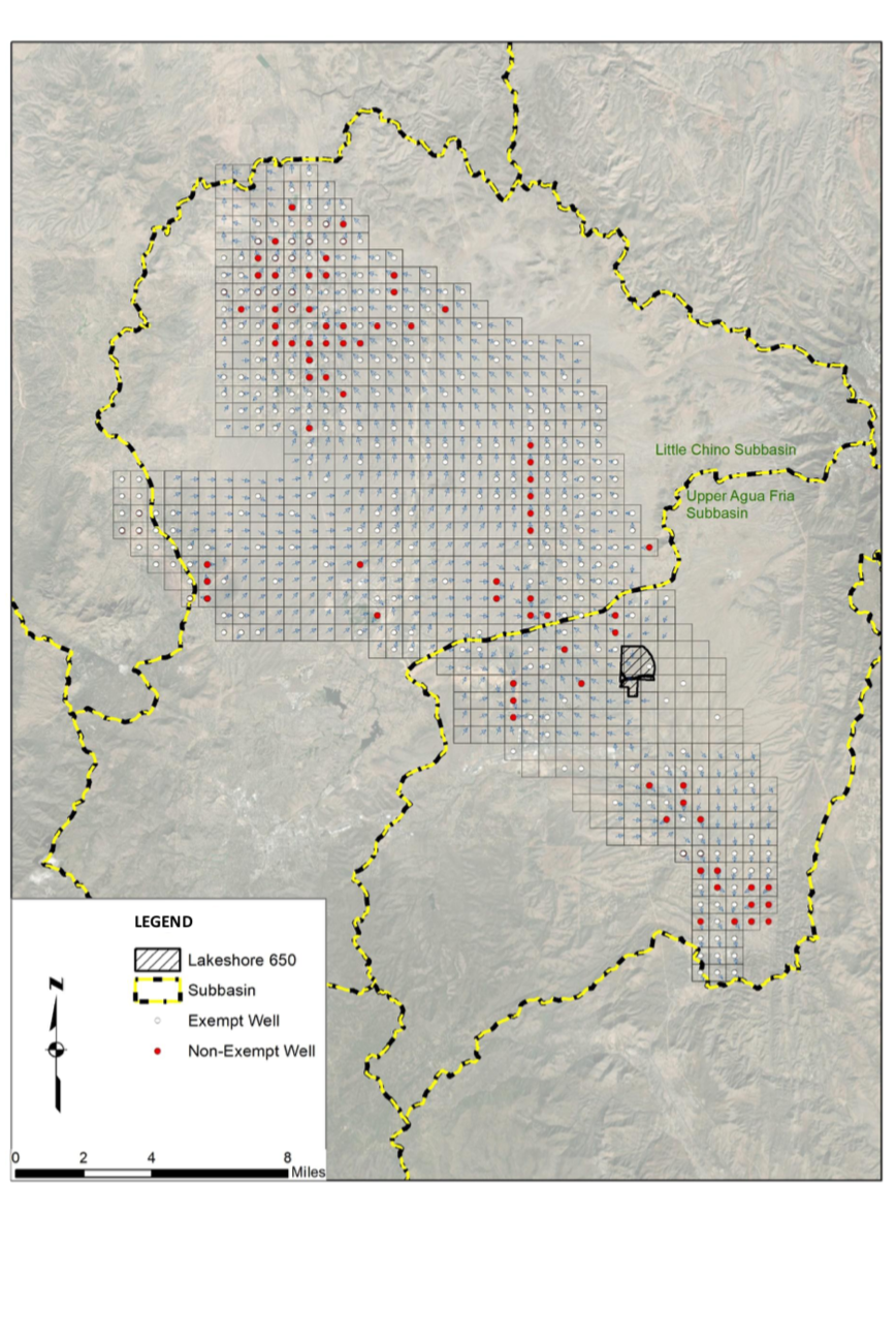
How many developers are claiming the same water from the 100-year assured water?
Each residential development in the PrAMA must account for existing groundwater demand and future committed demand. The existing groundwater model includes pumping for ~6,900 exempt wells (e.g., domestic-stock wells) and pumping to meet total demand for all AWS determinations at 100% build-out (~19,400 AFA). The additional demand of the project cannot cause other AWS wells to go dry or to exceed depth to water of 1,000 feet bls.
Simply put, none. They must all account for their additional water and cannot rely on water from other developments.
How does the hydrologist guarantee the data?
ADWR will review a comprehensive Hydrology Study prepared by a registered professional hydrologist (Matrix Engineering). In addition to describing site specific hydrogeologic conditions, the Study must use the 2021 Prescott AMA Groundwater Flow Model Update to demonstrate that the physical availability of groundwater to the Project meets the Assured and Adequate Water Supply Rules A.A.C. R12-15-701 through R12-15-730.
Infrastructure Questions
Who pays for the pipes to bring water to this development from Prescott valley?
Brown Homes and Fain Signature Group will pay for all utilities needed for the project both on and off-site (if necessary).
Will you drill a well?
Yes, the developer will be required to either drill a new well or provide from an existing well that is not currently in use. It will be based on the required water capacity study that will be done after zoning is approved.
Have water certificates been issued for this development or will they be on individual or community wells?
There are no water certificates issued for the development. It is anticipated to be one (or two) main supply wells that feed into a central distribution system.
Why does Prescott Valley have a recharge well?
Questions regarding the Town’s water infrastructure best answered by the Town
To address the current overdraft status of the Prescott AMA, Cities and Towns across the state have recharge wells to inject clean water into the aquifer.
How will water be recharged to the aquifer?
Sewer lines installed by the developer will flow to a new wastewater treatment plant (WWTP) at the project, or to the Town’s WWTP. The Town is permitted by ADWR to recharge effluent at the Upper Agua Fria Recharge Project (UAFRP).